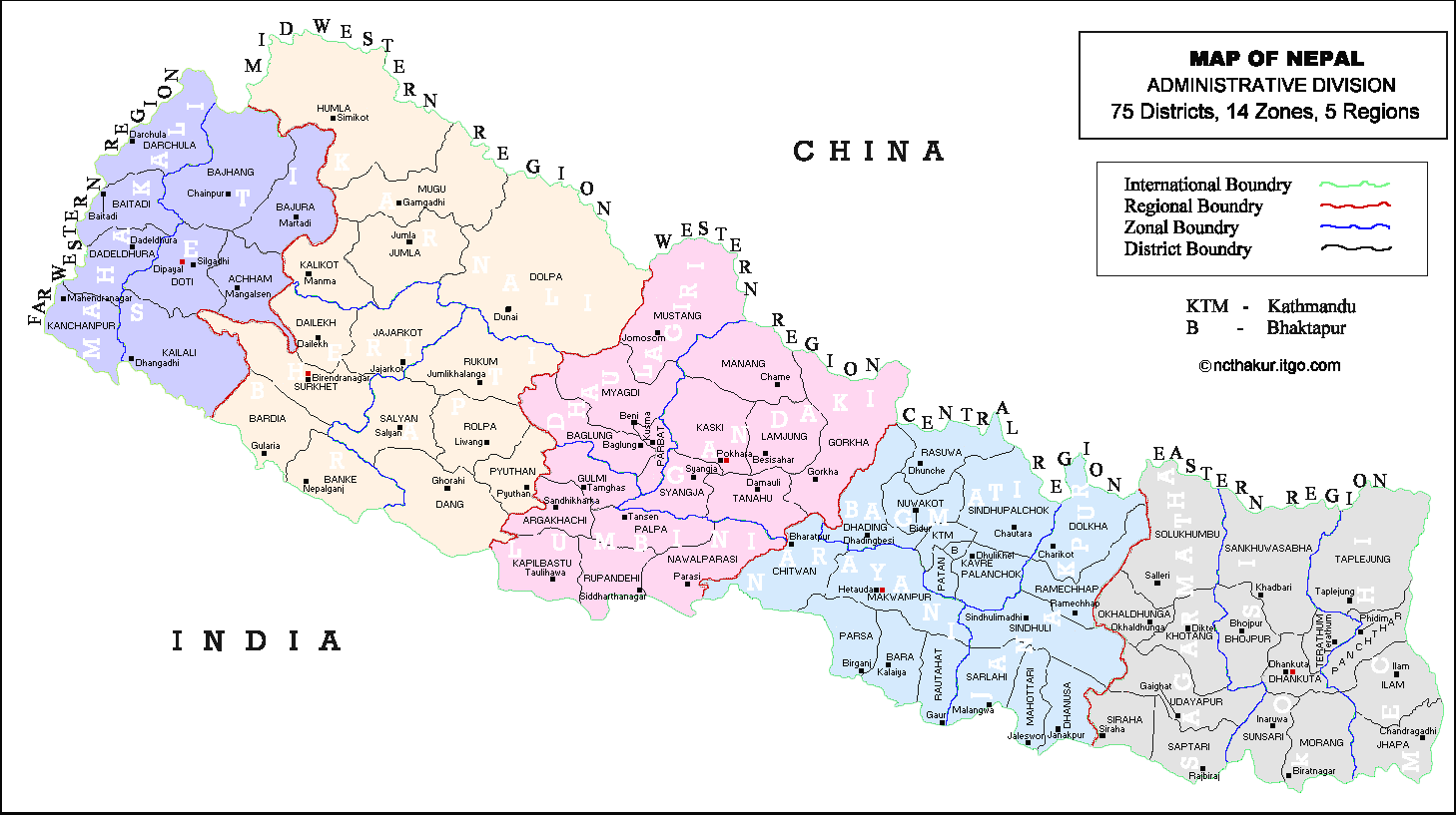
The Federal Democratic Republic, is located in South Asia. It is between China and India, roughly trapezoidal shape, BOO kilometers (497mi) long and 200 kilometers (124 mi) wide, with an area of 147,181 km2 (56,827 sq mi) and a population of approximately 27 million. It has exotic floras and fauna as well as interesting human settlements and cultures with 36 different ethnic groups. It is doubtless to say it is diversity in unity.
Mount Everest,the highest point of the earth is located in Nepal where tourists in large number visit to climb and see the Himalayan ranges , its natural beauty and historical sites.
Nepal is commonly divided into three geographical regions: Himalayan, and. The highest point is Mount Everest (8,848 m) and the lowest point is in the Terai plains of Kechana Kalan in Jhapa (60 m).
HIMALAYAN REGION:
The Himalayan region lies in the northern part of the kingdom. This region stretches from east to west. In the northern most part of this region,there are some of the highest peaks of the world. This part is always covered with snow. The southern part of this region is less cold. Himalayan region, crops are cultivated, animals are reared and carpets and wool are produced in large quantities.There are villages and small towns as well.
Himalayas are the Tibetan-speaking groups namely Sherpas,Dolpa-pas,lopes, Baragaonlis, Manangis. The Sherpas are mainly found in the east, Solu and Khumbu region;the Baragaonlis and Lopes live in the semi-deserted areas of Upper and Lower Mustang in the Tibetan rain-shadow area;the Manangis live in Manang district area; while the Dolpa-pas live in Dolpa district of west Nepal.
HILLY REGION:
The Hilly region is situated in the central part of the country. It spreads from Mechi in the east to Mahakali in the west. It has high hills and rocks. There are certain valleys surounded by hills from all sides. Kathmandu, Pokhara, Surkhet, Dang-Deokhuri, etc. are such valleys. The hilly region lies at a fairly high altitude. So this region has a moderate type of climate. It is neither too cold, nor too hot. There is heavy rainfall from June to September. It also receives winter rain. Moreover, Pokhara valley gets the heaviest rainfall in Nepal.
The main ethnic group Rai, Limbu, Tamang, Magar, Sunwar, Gurung and Chepang groups as well as other mongoloid groups live in this areas. The Brahmans, Chhetris, Newar and Thakuris and different occupational groups Kami, Damai, Sarki, Gaine are spread generally over most parts of the country. In towns Newar, Marbadi, Punjabi, Brahman, Kshetri and other mixed groups are also settled. The groups of Rai, Limbu, Gurung, Magar are popular as Gurkha solder in the world.
TERAI REGION:
The terai region lies in the southern part of the kingdom of Nepal. It spreads from Mechi in the east to Mahakali in the west. The terai in the east is wider – a than in the west. The southern part of the terai has fertile soil, while the northern part is full of stones, boulders and sands. The terai is situated at about 60 to 300 meters from the sea level. It has a hot climate. During summer,its temperature goes up to 40 degree Celsius. It receives rainfall during June to September. The eastern part of terai receives more rainfall than the western part. It is affected by floods during the rainy season.
The main ethnic groups in Terai are Tharus,Darai, Kumhal,Majhi,Dhimal, Sater,Jhagar, Koche,Meche, Rajbansiand other groups. They speak north Indian dialects like Maithili,Bhojpuri. Owing to the fertile plains of Terai, most inhabitants live on agriculture. There are,however,some occupational castes like Majhi (fisherman), Kumhal (potter) and Donuwar (cart driver).